We may earn revenue from the products available on this page and participate in affiliate programs. Learn More ›
Highlights
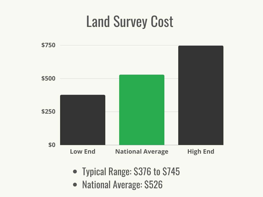
- The typical range for land survey cost is $376 to $745, with a national average of $526.
- Factors contributing to the overall cost of a land survey include lot size and shape, terrain and accessibility, research and travel time, time of year, survey type, and geographic location.
- Land surveys are needed before buying or selling property, building on a lot, adding a fence, subdividing, refinancing, obtaining an elevation certificate, settling property lines, and locating utility lines.
- A property owner can evaluate their property size independently, but they will need a professional surveyor to do an evaluation for it to be valid for legal purposes.
Determining property lines can help prevent future animosity by ensuring that a homeowner or their neighbors don’t erect a fence or other structure on the wrong side of the line. It’s also helpful to determine who’s responsible for tree removal or property maintenance. Homeowners can define their property lines by getting a land survey done. This legal document can describe property boundaries, geographic features, topography, and even property corners using GPS coordinates. So how much does a land survey cost? According to Angi and HomeAdvisor, the range is between $376 and $745, with an average of $526. The size of the property and the complexity of the terrain and existing boundaries will determine the final cost. Learn all about land survey costs here.
Factors in Calculating Land Survey Cost
The type of lot, along with its size, location, terrain, and accessibility, influences the cost for a land survey. Previous land surveys can help reduce the cost since the land surveyor can review previous documentation. Survey costs include the time the land surveyor spends evaluating the property on-site, researching property or geographic factors, and creating the report. Homeowners can request a quote from a land surveying professional or plug the following factors into a land survey cost calculator for a rough estimate.
Lot Size
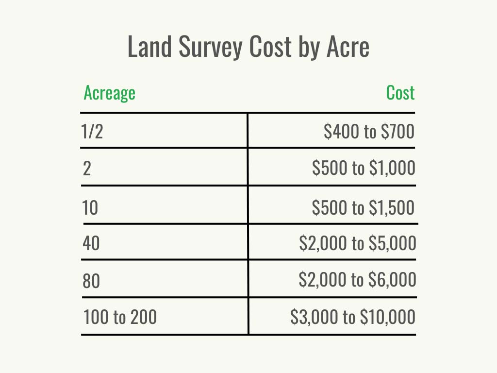
How much does a land survey cost per acre? Homeowners can expect to pay an average of $50 to $500. Most lawns in the U.S. are approximately one-fifth of an acre. The average reported costs for surveying these lots range from $400 to $700. Costs may also be calculated per square foot—usually between $0.15 and $0.70. The following chart shows the cost range for different property sizes.
Lot Shape and Dimensions
If the lot is part of a developed subdivision and a standard rectangle or square shape, the price will be on the lower end of the scale since it’s simpler to evaluate. New, uncleared, or odd-shaped lots will cost more, especially if they’re several acres. It may be worth it for a homeowner to pay the cost to clear land before the surveyor arrives. The first property survey on a plot will start from scratch and take longer to complete. Additionally, if the property has several points to establish, more time is needed to identify those boundaries correctly. If the property shape is irregular, in most cases every additional side will cost $50.
Terrain and Accessibility
Terrain and accessibility are two significant factors in determining land survey costs. If a buyer wants to purchase a property that isn’t cleared and has extensive property rights, the land surveyor will have to traverse the entire property to locate and record every major artificial and natural feature and boundary point. A rocky or densely wooded area will take time to work through. On the other hand, if a homeowner is having their existing property surveyed and has made several landscaping improvements or added structures, it will also take some time. The surveyor will need to add any features that are near property boundaries and establish their proper location. Working around any obstacles always costs more. The same principle applies for hills and slopes. Land that is excessively steep will cost an additional $100 per 10,000 square feet.
Research and Travel Time
If the property that is being surveyed is some distance from the land surveyor, travel fees will be added to the overall cost. Homeowners can search for “land surveyor near me” and ask for a quote that includes travel time. Additionally, land survey costs may increase by about $1,000 if the land surveyor has to do significant research to identify the boundaries. This is often the case when it’s a first-time survey or an old property with lost documents. If the original property markers are known, the homeowner will want to point them out to assist the surveyor. Providing plat maps for neighboring properties and personal property deeds can also help the surveyor get started.
Time of Year
It’s usually possible to save on the cost of a land survey by hiring a land surveyor at the right time of year. If the property is heavily wooded with deciduous trees, it’s advisable for a homeowner to hire the surveyor in the season when the leaves have fallen to allow a better line of sight. On the other hand, if the property is a wide-open space, spring or summer may be best so the surveyor can easily identify any property markers when they aren’t covered by snow.
Survey Type
There is more than one kind of land survey available. For example, a boundary survey is used to establish property lines when a property is being sold. A topographical survey accounts for any natural and man-made features that exist on the property. Depending on what the bank, buyer, or builder requires, it may be necessary for a homeowner to ask for a mortgage, boundary, subdivision, or another kind of survey. Each comes with its own associated costs and purposes but has an average price of $500. The major types of surveys will be covered in more detail below.
Geographic Location
Location will also affect the cost of land surveying. If a land surveyor needs to travel some distance to get to the property, this may incur extra for the associated travel fees. A land survey cost is also typically higher for metropolitan areas due to demand and the higher cost of living.
Additional Costs and Considerations
When budgeting for land survey costs, homeowners will want to consider a few less common factors that may apply to the situation. A survey may need a boundary line adjustment, or in some cases it’s possible to save on the cost of a new survey by having a recent one recertified.
Boundary Line Adjustments
There are times a boundary line needs adjusting. After the surveyor has established the boundaries of a property, they may need to correct an inaccurate line. This is usually added to the cost at a rate of $20 to $25 per hour. Alternatively, if a portion of the property is sold, a land surveyor will need to re-establish a new property line and update the plat map.
Recertification vs. Resurveying
In most cases, a land survey should be accurate for 5 to 10 years. To avoid additional land survey costs, homeowners will want to request a recent land survey to be recertified. This eliminates the need for a complete survey and reduces costs by 50 percent or more.
Special Services
Any services beyond the initial land survey may incur additional fees. This can include any extra maps or reports that a homeowner may desire. In some cases, the surveyor may be asked to share their findings with other stakeholders. This service is often charged as an hourly fee of around $120 to $150.
Types of Land Surveys
Boundary surveys are the most commonly requested land survey, but it may be necessary to request a topographic, mortgage, fencing, or ALTA survey. Another option is to request a simple staked site survey or get an updated plot map done. The following are the most common land surveys and their associated costs.
| Type of Land Survey | Average Cost |
| Additions | $500 |
| ALTA | $2,000 to $3,000 |
| As-built | $800 to $1,200 |
| Boundary | $100 to $600 |
| Fence | $250 to $1,000 |
| Mortgage | $500 |
| New construction | $1,000 to $2,000 |
| Plot plan | $75 to $200 |
| Plat | $10 to $30 |
| Staked site | $200 to $500 |
| Subdivision | $300 to $400 per lot |
| Topographic | $500 to $1,200 |
Additions
Any structure or feature being added that’s planned close to a presumed boundary line will need to have a property assessment done first. Having this done before building a pool, shed, or driveway could prevent a problem down the road. A survey will also clarify any local encroachment regulations about keeping structures a certain distance away from boundaries. Homeowners can expect this type of survey to cost around $500.
ALTA
Land owners who are looking to purchase or build on existing property for commercial purposes will be required to obtain an American Land Title Association (ALTA) survey. Surveyors will test soil composition, check floodplains, record topography, and note any features like utilities or septic tanks. Some homeowners may prefer to get an ALTA survey if they’re building a large house on terrain that could be unstable. ALTA land survey costs range between $2,000 and $3,000 and can take several months to complete.
As-Built
This is a high-tech method for determining an accurate 3D rendering of a house and helps determine how much space is available on the property if an additional structure is planned. Land surveyors use lasers to render a 3D model of the house—both inside and outside. The report should also indicate the location of any structure in relation to utility lines, walls, or property boundaries. This survey usually costs $800 to $1,200.
Boundary
A boundary survey is the standard method for determining where a plot’s legal boundaries exist. It’s common for homeowners to pay between $100 and $600 for a boundary survey. Each state has different requirements, but it’s in a buyer’s best interest to know precisely how much land they’re purchasing if they’re buying a house. Sellers will also be interested in a boundary survey since it ensures they can sell the property, since it allows them to price their property correctly and make sure they’re listing it for what it’s worth.
Fence
When building a fence, It’s essential to ensure it is being built along the correct property line. If a fence already exists, but its location is in question, often the best fence installation companies will require a fence survey. A land surveyor will check for property lines, plat maps, and original markers to discover whether a fence is in the right place. A new construction project usually has the original stakes intact, but it may be worth double-checking if there’s any question. A land survey for a fence will add $250 to $1,000 to the cost to install a fence.
Hydrographic
A hydrographic survey is used to measure a large body of water that exists on a property. It will document the depth of the water as well as any notable features along the water floor. A hydrographic survey is typically only necessary for land with a very large lake.
Mortgage
Occasionally, it may be necessary to request a mortgage survey. This is a reasonably straightforward survey that locates the property boundaries and any buildings on the lot, as well as identifies any extra considerations for a buyer to take into account, such as future septic tank costs if the home uses a septic system. It usually costs $500 to complete. For purchasing extended title insurance, a lender may require a mortgage survey as part of the approval process.
New Construction
A new construction project is one of the larger survey projects since a surveyor is usually starting from scratch. A comprehensive survey plan is put together to ensure each party (builder, engineer, lender, municipality) has the information needed to handle topography, boundaries, stakes, and location. New construction land survey costs usually add between $1,000 and $2,000 to the cost to build a house.
Plot Plan or Plat
A plot plan is sometimes mistaken for a plat survey; however, a plot plan only designates structures and buildings that do or will exist on the property. These plans are less exact than a plat survey and cannot be used as a legal document as a plat survey can. A plot plan costs $75 to $200. A plat survey will also include the surrounding area and typically only costs $10 to $30.
Staked Site
Land surveyors are used during a new construction project to designate the boundaries of a new plot by staking out the corners. They also mark where sidewalks, buildings, or roads will be. If the home has numerous corners or indentations, it will take longer and cost more to stake the site. Staking a site costs $200 to $500 on average and is similar to a boundary survey.
Subdivision
Developers use subdivision surveys to determine individual plots of land. After they’ve determined how much is an acre of land, they’ll figure out the best acreage per parcel and request a survey to plan and designate each parcel. If a homeowner is in an existing subdivision and their land crosses in front of a neighbor’s driveway, the neighbor may be granted rights of access as a result of a land subdivision survey. Homeowners can expect to pay $300 to $400 for subdivision surveys depending on how many buildings or lots are included.
Topographic
A topographic survey is used when an area of land is being assessed for development, whether commercially or privately. It could be required by local authorities, engineers, or architects. The average cost of a topographic survey is $500 to $1,200 for lots under 10,000 square feet. Any artificial or natural features like rocks, streams, trees, elevations, fences, or buildings are recorded.

Do I Need a Land Survey?
It can seem like a hassle to hire a survey company, but paying a small fee for land survey costs up front can help prevent potential legal fees for homeowners in the future. In certain situations, it’s even required to get a land survey done before moving forward with a project or financing. The following are some of the top reasons a homeowner may need to hire a surveyor.
Selling Property
Selling a house is a major legal transaction that has numerous hidden costs. Not having documentation to back up claims about the exact property dimensions could lead to legal disputes later on from an unhappy buyer. In some cases, a land survey could reveal that a property is larger than the owner originally thought, making it possible to sell the house at a higher price. Having proof that a property is the size that is listed will instill confidence in the buyer that they’re getting a fair deal.
Buying Property
Buying a property is one of the most significant transactions in life, so it’s essential for a home buyer to know exactly what is being purchased. A key benefit to getting a property survey first is that it will expose any existing encroachments, easements, or access rights. It’s vital for a buyer to know ahead of time if a neighbor has water rights or if their driveway crosses the home’s land to avoid legal disputes later.
Building Property
Avoid extra construction costs by making sure structures or features are being built along the legal boundary. It’s never fun to have to tear out a shed or pergola and move it when a survey could have prevented the entire hassle. A surveyor can work with contractors to make sure the pergola or shed is placed correctly.
Fences or Additions
The same problem applies here to fences or any additions. Without being sure of the legal boundary, a homeowner could wind up in legal hot water for building a structure that encroaches on their neighbor’s property. Being on good terms with the neighbor now doesn’t mean that things won’t change if they want to build a structure or if they sell the house and find they have less property value.
Subdivisions
Any kind of subdividing, whether by a developer or a private owner selling portions of his own land, will require a licensed surveyor to assess the property and create new boundaries. Easements, titles, planning restrictions, and utilities are all considered to make sure each plot is legally defined.
Refinancing
If a homeowner is looking to refinance their home or property loan, but their last land survey is several years old, the lender may require them to complete a new survey. Since loans are based on the property’s value, lenders only like to loan the exact amount of money, so having an updated survey helps ensure the property value is accurate.
Obtaining an Elevation Certificate
Some homes are built in high-risk areas like on a floodplain or at a lower elevation. Homeowners insurance will likely request an elevation certificate from a licensed surveyor before setting a flood insurance premium if one is required. The insurance company needs all the information about the flood risks in the location.
Finding or Settling Property Lines
No matter how sure a homeowner is about their property lines, a neighbor could be just as confident with a different opinion. Over time, markers could be moved or lost, so it’s difficult for either to know for certain. Getting a boundary survey is the best way to settle disputes about property lines since it’s a legal document outlining the boundaries using original documents.
Locating Utilities
Before digging on any property, a homeowner or contractor will need to locate buried utility lines. Assessing a property will help establish where utilities are located. Contractors will need this information for new construction projects or extensive renovations.

Land Survey: DIY vs. Hiring a Professional
It’s easy to do a quick assessment of how big a property or structures are using measuring tape and lasers, but these findings won’t hold up in a legal dispute. Since property boundaries are tied to high-value assets, only licensed surveyors can conduct surveys to establish the value and size of the land. A DIY survey will not qualify for use in a property sale, and it likely won’t include any records of easements or rights-of-way. A professional understands how to find property lines while homeowners are more likely to make a mistake.
Some surveys require extensive research and expertise in geologic principles. Licensed surveyors complete schooling and training to be legally certified as land surveyors. This also means the legal burden is on them. If a homeowner needs to use a property survey in a court of law, the surveyor is liable for an inaccurate assessment, not the homeowner. Land survey costs are simply one of the necessities of dealing with property assets, and leaving the complicated job to an expert is the best choice.
How to Save Money on Land Survey Cost
Land survey costs are fairly standard across the board in the sense that prices are influenced by a similar number of factors no matter the location. Since DIY-ing a legal land survey is out of the question, consider these ideas for saving money on land survey costs.
- Shop around: Obtain as many quotes as possible. Be sure to ask about any add-on fees, like those for travel, research, and terrain.
- Consider seasonality: Try to request a land survey at the cheapest time of year for your location.
- Get a referral: Ask your real estate agent for a surveyor they recommend. They may offer a referral discount.
- Be prepared: Obtain as many documents about your property as possible ahead of time, and provide the surveyor with a copy of them. Share as much information about the property as possible to save the surveyor time.
- Clear the land: Remove as many obstructions as possible to make it easier for the surveyor to get to your property boundaries. It may be worth the cost of landscaping to have this done by a professional ahead of time.
- Consider other options: Ask if less costly recertification will provide the information you need rather than paying for a new survey.
- Choose services wisely: Only request the kind of survey you actually need, not the most extensive one.
Questions to Ask About Land Surveys
Property surveys can be a complex task for some property owners. Homeowners will always want to make sure the surveyor is licensed and insured in their state before hiring to avoid any problems later on. Some of the best landscaping companies offer this service, but often homeowners will hire someone who specializes in this service. Asking these other questions ahead of time will help avoid miscommunication and achieve the desired results without wasting money.
- Do you have references I can speak with?
- What kind of survey do I need if I’m trying to determine existing property lines?
- Have you completed this kind of survey before?
- How do you determine the cost for this survey?
- How much are your travel fees?
- What other add-on charges will be included for this kind of survey?
- What’s the estimated cost, and can I see a line-item quote?
- Do you offer any seasonal discounts?
- How many employees will you send on this project, and how experienced are they?
- How long will this job take?
- When can you start?
- What documents will I receive with this survey?
- Will you notify me of any local laws about encroachment?
- What do you recommend as the next steps if you discover a property boundary error?
FAQs
Several land survey options are available, so it’s important for a homeowner to choose the right one while staying within their budget. The following are the answers to the most frequently asked questions to help guide the process.
Q. Can I do my own property survey?
Homeowners can complete their own surveys when they measure how much space they have to build a deck or patio. There’s certainly no law against a homeowner checking how much space they have within their own property. What isn’t allowed is measuring the property and using those findings as legal documents. Since property is an expensive asset, only licensed professionals can conduct legal surveys to determine legal boundaries that affect property value. Professional surveyors are also skilled and trained at evaluating difficult terrain for construction projects as requested by engineers and lenders.
Q. What does a land survey include?
It depends on the kind of land survey. Most homeowners need a boundary survey that identifies the exact locations of their boundaries with a legal description. They’ll also include any right-of-way access or other easements. More extensive surveys like topography or ALTA surveys assess the terrain, ground stability, natural and manufactured features, and property rights. Homeowners can do an online search for a “survey company near me,” and talk with a pro to find out which kind of survey is the best fit.
Q. Is a land survey more expensive for a bigger plot of land?
In general, yes. It costs anywhere from $50 to $500 per acre to conduct a survey, but that’s also dependent on how complex the terrain is. Some surveyors may charge a flat fee for a home in a standard-size subdivision, but any unusual or large properties will cost more to survey.
Q. How long does a property survey last?
In most cases, a survey will be considered valid for between 5 and 10 years. This will depend on the surveyor who performed the survey and how long their liability is valid.
Q. Does a buyer or a seller pay for a property line survey?
Typically, a seller will pay for the survey as a way to move the deal forward, although this is not a legal necessity.
Sources: HomeAdvisor, HomeGuide, Angi